Tag Archive for 'original reporting'

Drawing conclusions from the Death Dashboard

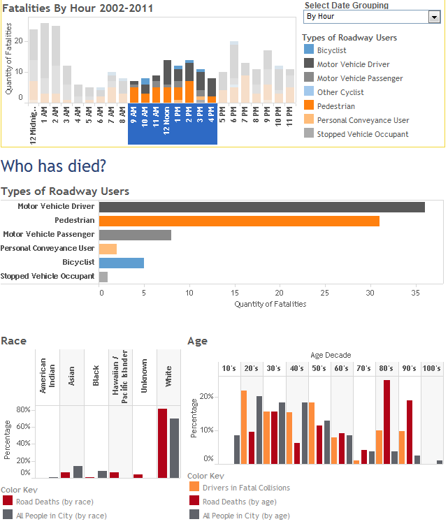
The Seattle Roadway Death Dashboard published here last week combines different sources of data and presents the data through various chart types. This interactive analytical tool provides information on roadway fatalities that could be used to save lives.

Here are some examples of how you can interact with this tool to gain insight:

  • During the daytime, people in their 80s and 90s are more likely to be killed in a traffic collision than any other age group. Together, this age group makes up 7% of the total population but accounts for 44% of the fatalities from 9am to 4pm.
    [expand title=”see screenshot”]
    Dashboard showing daytime fatalities between 9am to 4pm.

    Dashboard showing daytime fatalities between 9am to 4pm.

    [/expand]
  • Pedestrians 50 and older are disproportionately likely to be killed on Seattle roadways. Pedestrians younger than 50 count for fewer roadway fatalities than expected based on the city demographics. People aged 20-49 account for 58% of the city population but only 41% of its pedestrian fatalities.
    [expand title=”see screenshot”]
    Death dashboard showing pedestrians only by age and race.

    Death dashboard showing pedestrians only by age and race.

    [/expand]
  • As a percentage of total fatalities, black drivers are more than three times as likely to be killed on the roadway than city demographics would suggest. This race accounts for 26% of driver fatalities but only 8% of the population.
    [expand title=”see screenshot”]
    Dashboard showing drivers only by age and race.

    Dashboard showing drivers only by age and race.

    [/expand]
  • Rainier Ave S is the deadliest city street with a speed limit from 20-35 mph by far, but there are several other streets where four or more people have died.
    [expand title=”see screenshot”]
    Death Dashboard showing fatalities on roadways with 20-35 mph speed limits.

    Death Dashboard showing fatalities on roadways with 20-35 mph speed limits.

    [/expand]
  • Pedestrian fatalities are fairly evenly distributed throughout the day, while driver and passenger fatalities occur predominantly late at night and in the very early morning.
    [expand title=”see screenshot”]
    Death Dashboards showing pedestrian fatalities by hour - fairly evenly distributed.

    Death Dashboards showing pedestrian fatalities by hour – fairly evenly distributed.


    Death Dashboards showing driver and passenger fatalities by hour - mostly at night.

    Death Dashboards showing driver and passenger fatalities by hour – mostly at night.

    [/expand]

This is just a sampling of the type of analysis you can do with the dashboard. Please share any interesting results you’ve found in the comments.

Share

Seattle Roadway Death Dashboard

This dashboard provides a visualization of 299 roadway fatalities that occurred in Seattle from 2002-2011.

Share

Walking in Europe

I recently spent three weeks in the British Isles and Paris with an eye on the pedestrian experience. Now back in Seattle, I’m here to share what we have to learn from Europe (and what they could learn from us).

While Seattle is thought of as a pedestrian-friendly city in America, the experience walking in Seattle is very different than walking in the walkable European cities of Dublin, London, and Paris.

Seattle pedestrians are known for our almost robotic patience in waiting for the walk signal. On my visit to Europe, it took a while to get used to the fact that nobody, other than tourists, waits for the signal.

Walking is often called a mode of active transportation but it definitely felt more active in Europe than in Seattle. Watching for traffic, sidestepping slow moving locals and lost tourists, and hopping between narrow sidewalks and narrow roadways meant walking in Europe took more effort. It feels pretty passive by comparison to ignore cars and thoughtlessly obey crosswalk signals while walking here in Seattle.

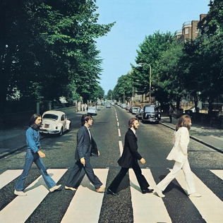
Abbey Road cover, photo taken in London

Crosswalks like this (and albums like this) are not the norm in London

While urbanists often consider America as having poor pedestrian infrastructure, the experience is different between the continents. Crosswalks as shown on the cover of Abbey Road are the exception in England. Crossing is often done at your own risk, as pedestrians aren’t given the right of way like they are here and road markings for pedestrians are fewer and less clearly marked.

Marked pedestrian crossings can be far apart, and crosswalk signals often have a long wait for a short time to cross. Jaywalking in the British Isles was made easier by helpful labels on the pavement telling you which way to look.

Helpful street markings for jaywalkers

Helpful street markings for jaywalkers

Some areas had few crossings of major streets, like parts of downtown Dublin, giving pedestrians limited options for walking. In contrast, Edinburgh had plenty of narrow pedestrian alleys, called closes. While walking down small dark alleys wouldn’t be a comfortable experience in most parts of America, feeling safe, was never an issue in the northwestern part of Europe. In the many pedestrian areas that I walked through, there were very few beggars, homeless, or mentally unstable individuals. Not being asked for money or otherwise interrupted by someone on the street seemed to make for a much more comfortable pedestrian experience. We don’t often consider homelessness in the context of the pedestrian streetscape, but there is a relationship there that is worth consideration.

Trafalgar Square in London

This is far from Westlake Park

As far as the built environment goes, there were some pedestrian only areas like Grafton Street in Dublin, the Shambles in York, and parts of the Latin Quarter in Paris that were highlights of their respective cities, but I felt the well-used public living rooms were an even better pedestrian amenity. From busy squares in York and the crowded but comfortable Trafalgar Square in London to the River Seine with hundreds of Parisians enjoying their wine and cheese at sunset, there are no public spaces in Seattle that compare, and certainly not our busiest public parks like Victor Steinbrueck Park and Westlake Park.

Those great public spaces and pedestrian streets make the biggest difference in making walking in Europe more pleasant than walking in Seattle, but their success isn’t due as much to the architects that designed them as it is where they’re located. In the next post, I’ll share some lessons I learned from the European transportation infrastructure and how our focus is wrong if we want a similar experience here.

Share

2012 Worst Intersection in Seattle: 5th and Denny

5th and Denny, no crossing

The worst intersection in Seattle

The 2012 winner of the Worst Intersection in Seattle is 5th and Denny. This intersection has a lot going for it, but a missing crosswalk and a dangerous one, along with a pedestrian signal that works only if someone hits the button, impede mobility in the area and undermine the city’s efforts to promote walkability.

You could pick dozens of bad intersections in Seattle from an era of car-friendly road building. However, in the case of 5th and Denny, the concrete that was poured decades ago isn’t the biggest problem; it’s the regulated, almost deliberate hostility to pedestrians in an area that demands the opposite. Four blocks away from last year’s worst “intersection” of Aurora and its non-crossing cross streets of John, Thomas, Harrison, and Republican, 5th and Denny is an active intersection for multiple modes of transportation in a very walkable area in the heart of the city. The sidewalks are relatively wide and smooth and the intersection has two plazas and street-friendly retail.

5th and Denny push button

Push to cross

Bordering Belltown, this intersection is host to substantial foot traffic from residents. Unfortunately, pedestrians aren’t allowed to cross Denny on the east side of 5th/Cedar, and instead must cross three streets instead of one. On southeast-bound 5th Avenue, which some call the “5th Avenue onramp,” pedestrians are forced into areas outside drivers’ lines of sight and cars veering onto Fifth speed by.

One of the most remarkable problems of this intersection is the one that is the easiest to address. People trying to cross Denny often find themselves stuck waiting for the signal to change, not realizing that they have to push the button to cross.

5th and Denny looking northwest

This intersection has potential

In much of this area near the Space Needle and multiple hotels, tourists from Tucson to Toronto and Spokane to Sequim experience what walkable, urban, Seattle has to offer. With high pedestrian traffic, frequent bus service, and the monorail soaring overhead, this intersection could serve as an example of what a pedestrian-friendly city can be like. However, the 5th and Denny intersection treats them like second-class citizens with the same “no pedestrians” sign they might see if trying to cross a freeway in Fargo and the same push button signals they would use to cross an 8-lane suburban highway in Houston.

For all of Seattle’s progressive urban undertakings – greenways, road diets, and the proposals to lift parking requirements – what does it say about the city if we can’t be practical enough to make an important urban intersection work well for walkers? What does it say if we don’t allow pedestrian to cross an urban intersection without hitting a button? What does it say if we’re ok with pedestrians being forced to cross three streets instead of one? What does it say if we allow pedestrians to be hidden behind a pillar?

It says that despite the city’s progressive urban ambitious, we will never reach our potential as a city until we rethink intersections like 5th and Denny that put cars first and put pedestrians last.

Share

Road diet on Nickerson found to improve safety, will other streets get a road diet?

SDOT has released a report on the Nickerson St road diet and found that by reducing the number of lanes for cars, safety has improved. Collisions, overall vehicle speeds, and the number of speeders have been reduced with minimal impact to traffic volumes. The Mayor outlines the good news:

Completed by the City in August 2010, the modifications have produced the following results:

  • Reduced collisions by 23 percent over a one-year period (compared to the previous five-year average)
  • Motorists traveling over the speed limit have declined by more than 60 percent
  • Top-end speeders (people traveling 10 or more miles over the speed limit) have fallen by 90 percent
  • The 85th percentile speed dropped from 40 mph and 44 mph westbound and eastbound to 33 mph and 33 Westbound and Eastbound. This is an 18 and a 24% reduction in speed.
  • Traffic volumes remain roughly the same with no evidence of traffic diversion.

This is the 27th successful road diet implemented by SDOT since 1974. And, with yet another roadway safety measure in place, the question must be asked: why isn’t SDOT implementing more of these safety measures?

We recently pointed out that 28 pedestrians have died in locations that may be eligible for a road diet. Since then, we’ve profiled three streets that may be ideal candidates for SDOT to consider next: 35th Ave SW in West Seattle, 23rd Ave in the Central District / Judkins Park, and S Jackson St in the International District. Let’s compare these three streets with Nickerson St to see whether these other streets may deserve the same successful safety treatment as Nickerson and 26 other Seattle streets.

First, we’ll start by looking at traffic volumes. SDOT looks at the total number of cars that use a roadway before implementing a road diet. Streets with average daily traffic counts above 25,000 are not good candidates, and presumably lower volumes make for better candidates, though road diets have minimal impact on overall volume. Using SDOT’s 2010 traffic volumes, here are the four streets compared, from lowest volume to highest:

  1. Jackson St: ranges from 10,200-13,600
  2. 23rd Ave: 13,400
  3. 35th Ave SW: ranges from 16,100-22,700
  4. Nickerson St: 22,300

Let’s look at another metric. While Walk Score is not an official criteria used by SDOT, it indicates the walkability of a location and is correlated with the number of pedestrians in an area. Streets with more pedestrians may be more deserving of measures that make the pedestrian environment safer and more pleasant. We took a sample Walk Score of 2-3 locations along each of these streets and are ranking them from highest (most walkable) to lowest (least walkable).

  1. Jackson St: 90
  2. 23rd Ave: 86
  3. Nickerson St: 81
  4. 35th Ave SW: 75

While the last two comparisons were interesting, the primary purpose of a lane rechannelization is to improve safety and the most dangerous streets should be looked at the hardest. We looked at this map of nationwide road fatalities, and counted the deaths that have occurred on each of these roadways from 2001-2009 to rank them in terms of urgency for safety improvements:

  1. 35th Ave SW: 4 roadway fatalities (including 2 dead peds)
  2. 23rd Ave: 4 roadway fatalities (2 dead peds)
  3. Jackson St: 3 roadway fatalities (3 dead peds)
  4. Nickerson St: 1 roadway fatality (0 dead peds)

Of our comparison group, Nickerson St has been the safest, is the second least walkable, and has the highest traffic volume. Still, a road diet was implemented and now has been shown to be a success. If a road diet can work there, then surely it can work on these other streets. How many more people will have to die before SDOT implements road diets on 35th Ave SW, 23rd Ave, Jackson St, and other locations where people are killed on Seattle’s roads?

Share

Deadly Seattle Street: S Jackson St in the ID

Walking in Seattle is profiling some of Seattle’s deadly roadways that could be candidates for a lane rechannelization, or road diet.

A road diet involves restriping the roadway, often to add a center turn lane and bike lanes. The effect is that vehicles slow down and the roadway is safer for all users. SDOT considers a roadway a good candidate for a road diet if people often speed on the roadway, if there is a history of collisions, and if a road diet wouldn’t significantly impact traffic volumes.

Jackson St at 5th Ave

Jackson St at 5th Ave

Walking in Seattle nominates Jackson St in the International District as a good candidate for a road diet.

From 2001 to 2009 there have been three pedestrian fatalities along Jackson. At 5th and Jackson a 74-year-old woman was killed at 11:30 on a Friday in February. Later that year, an 81-year-old man was killed at Jackson & 10th on a Wednesday morning in June. In 2002, a 69-year-old woman was killed as well.

The roadway currently has four lanes of traffic, with parking lanes on each side, yet only carries 10,200-13,600 vehicles daily, far below SDOT’s maximum limit of 25,000 vehicles for implementing a road diet. While a road diet may not have prevented these fatalities, road diets have been proven to improve safety. Automobile speeds are lower and less variable, and bicycle lanes help make the roads safer for more users. By lowering vehicle speeds, pedestrians are safer as well – a pedestrian struck by a vehicle traveling at 40mph is 85% likely to die, however if the vehicle is only going 30 mph, the pedestrian has a 50-60% chance of survival.

Jackson St, like 23rd Ave and 35th Ave SW, is a street that should be made safer and should be considered for a road diet.

[poll id=”14″]

Share

Deadly Seattle Street: 35th Ave SW in West Seattle

35th Ave SW, a good road diet candidate

One of Seattle’s deadly streets that deserves more attention is 35th Ave SW in West Seattle. This street appeared twice in our list of locations of fatal pedestrian collisions that deserve further study. Walking in Seattle nominates this street for special consideration by SDOT as a road diet candidate.

A lane rechannelization, or road diet, involves re-striping the roadway, and in the case of 35th Ave, would add a center turn lane and bike lanes, and have one lane in each direction for motor vehicle traffic. The effect is that traffic flows more smoothly, thanks to the center turn lane, drivers go more slowly, and all users are able to use the roadway more safely.

The road carries 4 lanes of vehicle traffic in addition to a lane of parking on each side of the street. This makes the road width around 54 feet, which takes someone walking a normal speed more than 13 seconds to cross – a long time to be in the middle of a deadly roadway. In one area, marked crosswalks are half a mile apart.

An 85-year-old man was struck and killed on this street in 2007 at SW Othello St. A 39-year-old man was also killed on this street when he chased after his dog. This incident was covered by West Seattle Blog when it happened. While the speed of the vehicle who hit him isn’t available, road diets do reduce vehicle speeds. A pedestrian hit at 40 mph is about 85 percent likely to die; a pedestrian hit at 30 mph is about 40 percent likely to die.

Between 2001 and 2009 there were also two non-pedestrian fatalities on the roadway as a 27-year-old female cyclist was struck and killed at SW Graham St in 2006 and a 77-year-old driver was killed in a collision at SW Thistle St.

According to SDOT’s traffic volume data, the daily traffic volume on this road ranges from 16,100 to 22,700 vehicles per day. SDOT’s maximum threshold for implementing a road diet is 25,000 vehicles per day.

Right now the road has no bike lanes or sharrows and limited crosswalks. While it’s not certain that a road diet would have prevented these needless deaths, safety improvements are needed and could be provided by a road diet.

What do you think?
[poll id=”12″]

Share

Could road diets have saved the lives of 28 pedestrians?

Walking in Seattle analyzed pedestrian fatality data* from 2001 to 2009 and found that 28 of Seattle’s 90 fatal pedestrian collisions occurred on roads that may be eligible for a lane rechannelization.

A lane rechannelization, or road diet, involves re-striping the roadway, often to add bike lanes or reduce the number of lanes for motor vehicles, with the intent of improving safety by slowing vehicle speeds and shortening crosswalk distances.

Through usually controversial when proposed, 26 road diets have been successfully implemented in Seattle since the 1970s. Streets that have recently been rechannelized include Stone Way, Fauntleroy Way, Nickerson Street, and 125th Avenue. According to pro-pedestrian organization Feet First, “When [road diets are] done properly at appropriate locations, all users benefit.”

One benefit of a lane rechannelization is lowered speed. The road diet on Nickerson Street has dropped motor vehicle speeds from 40-44 mph to 34-37 mph. A pedestrian hit at 40 mph is about 85% likely to die; a pedestrian hit at 30 mph is about 40% likely to die.

Since the road diet on Stone Way, Seattle’s Department of Transportation reports that collisions on that street have dropped by 14%, injury collisions have dropped by 33%, and collisions with pedestrians have dropped a full 80%!

SDOT doesn’t have a specific road diet program, but “we have been using rechannelizations as part of our paving program or proactively as part of other work,” says spokesperson Rick Sheridan. A road diet is a relatively inexpensive and reversible way to compensate for shortcomings of the roadway design and “one tool to improve safety through traffic calming.”

SDOT considers a roadway eligible for a road diet if vehicles routinely exceed the speed limit, if there are a history of collisions on the roadway, and if the lanes can be reduced without significantly impacting the current travel volume. SDOT considers 25,000 vehicles per day as a maximum volume for a four-lane roadway to receive a lane rechannelization.

Walking in Seattle has applied the above criteria to the 104 pedestrian fatalities (a result of 90 collisions) that have occured from 2001-2009 to come up with a list of roads that could be eligible for changes to the roadway striping. We feel that 28 of these collision sites deserve further study by SDOT:

Date of Collision Street Name Neighborhood 2010 Traffic Volume** Walkscore at Fatal Collision
9/12/2001 5th Ave Downtown 10800 100
9/23/2001 SW Alaska West Seattle N/A 86
6/7/2002 S Jackson St International District 13600 83
7/31/2002 35th Ave NE Wedgwood 15400 69
11/2/2002 35th Ave NE Wedgwood 15400 77
1/5/2003 S Jackson St International District 13600 86
6/16/2003 5th Ave Belltown 10800 98
7/3/2003 NE 130th St Haller Lake 19900 37
12/21/2003 Rainier Ave S Rainier Beach 18000 68
10/1/2004 15th Ave NE University District 8900 97
1/5/2005 Swift Way Beacon Hill 7400 71
11/10/2005 E Cherry St Central District 8300 86
12/14/2005 Alaskan Way Downtown 12600 82
2/8/2006 Rainier Ave S Brighton 23900 51
11/2/2006 4th Ave Downtown 18600 98
11/14/2006 SW Admiral Wy Admiral N/A 80
4/21/2007 24th Ave E Montlake 20000 62
10/27/2007 35th Ave SW High Point 20200 65
11/20/2007 16th Ave SW 98146 5100 71
12/19/2007 Pinehurst Wy NE Northgate 10900 86
1/4/2008 23rd Ave S Atlantic 13400 85
3/30/2008 1st Ave S Pioneer Square 24700 83
6/25/2008 Des Moines Memorial 98108 N/A 52
8/10/2008 35th Ave SW North Delridge 22700 48
8/23/2008 E Madison St First Hill 21900 98
9/22/2008 California Ave SW West Seattle 12600 85
6/17/2009 S Jackson St International District 13600 83
11/11/2009 NE 50th St University District 21800 98

Many of these roads have four lanes of vehicle traffic and could have a center turn lane added, similar to other road diets. Some of these locations only have two lanes of traffic, like California Ave and Adrmiral Way, however the current lanes are wide and encourage higher speeds. By adding bike lanes and striping the parking lane, the main road space would be constrained and drivers would slow down.

While the city has been falsely accused of waging a “war on cars” through implementation of road diets, these statistics suggest that the city’s efforts have not been aggressive enough at reducing roadway fatalities.

Share

Feet First: Working on behalf of walkers

I recently sat down with Lisa Quinn, Executive Director of the non-profit organization Feet First which celebrated its 10 year anniversary recently. We discussed the organization’s current projects and future plans, and also talked about ways people can get involved.

Feet First’s mission statement is “Creating Walkable Communities.” The organization performs walking audits, creates walking maps, participates in community events, works with cities to provide input on pedestrian plans, and promotes safe walking routes to schools.

Safe Routes to School is a major focus for Feet First. They helped 61 schools across the state participate in International Walk to School Month. In Seattle, Feet First is a consultant for Olympic Hill, Roxhill, Dearborn, and Hawthorne Elementaries. The group will soon provide a neighborhood walking map for the area around Concord International School.

Quinn describes how Feet First’s school consultancy program works. “First, we take a step back and do a strengths, weaknesses, opportunities, and threats analysis, and then we do a walking audit, and from there we are able to map out what we want to do for a school.”

“Schools may want a walking school bus, but they take a step back, they realize it’s not going to work, and what they really need is better signage…with our walking audits, it really helps the community be engaged in what outcomes they want to see,” she says.

Feet First is working with eighteen schools in South King County to identify walking audit routes and make recommendations. For each audit the organization works to foster communication between diverse groups including city planners, representatives of the school district, parents, and teachers. City of Renton planners are using Feet First’s walking audit report as a checklist of issues to address.

Compensation for many of Feet First’s paid staff comes from grant funding. Recently, this funding allowed the organization to hire a walking ambassador program coordinator. There are twenty trained ambassadors who lead walks in their neighborhoods and produce a number of published walks each month.

The ambassador training process, Quinn says, is “not just showing how to lead a walk, but giving people tools and knowledge on how to advocate for better conditions in their neighborhood.” Information about the ambassador training program can be found on Feet First’s website.

Feet First recently adopted and released an official Agenda outlining the group’s mission, goals, and specific initiatives for cities. The group’s evaluation of cities in the region concluded that Bellevue, Kirkland, Redmond and Seattle already follow the outlined strategies. These four cities have been recognized as Feet First Agenda Cities. The current goal, Quinn says, is to get five more cities to commit to meet the nine criteria and “pass a resolution acknowledging that they are Feet First agenda city and that they are making a commitment to continue to build a walkable community.”

Feet First’s approach has to implement small programs, learn from them, and grow gradually. Because of that, Feet First is not yet well known across the region. Quinn says, “Unlike bicycle organizations like Cascade, which has over 13,000 members, we don’t have that critical mass–except everyone’s a pedestrian.”

While Quinn sees a lot of similarities between the Cascade Bicycle Club and Feet First, she says getting people to identify as pedestrians has been a challenge almost like “herding cats.”

Feet First currently has about 100 registered members and they are holding a membership drive during the month of December to grow that number. Their website explains the three different levels of membership, including the benefits that new members would receive if they join this month. The organization is also welcoming volunteers to staff event tables, write blog articles, participate in the safe routes to school program, and attend public meetings. More information about these and other volunteer opportunities are listed on their website.

The organization’s current walking maps are available for download, and their walking maps for West Seattle are on display at eight kiosks in the neighborhood. In the coming months, Feet First will examine the potential of engaging walkers through technology. The organization is investigating creating their own mobile app that pedestrians could use to identify areas that present challenges for walkers.
Share

Natural drainage systems in sidewalk construction

In Crosscut, Roger Valdez looks at the impacts of traditional sidewalks on the environment. A Washington State Department of Transportation study unsurprisingly shows a benefit from installing sidewalks.

Here’s the key paragraph from the study:

The results provide early evidence in the potential effectiveness of sidewalks to reduce CO2 and VMT [vehicle miles traveled], in addition to a mixed land use pattern, shorter transit travel and wait times, lower transit fares and higher parking costs. Sidewalk completeness was found to be marginally significant (at the 10 percent level) in reducing CO2, and insignificant in explaining VMT.

In this sense the term “marginally” might read as “small.” But in a research context “marginally significant” also means sidewalks can make a difference along with other factors to significantly reduce CO2 emissions.

However, pavement is impermeable, blocking rainwater from being absorbed by the ground and redirecting it to the storm sewers that send it to Puget Sound.

After it rains, water hits all that pavement and it starts rolling around, picking up the petroleum drippings from cars, pesticides from lawn care products, and a legion of other things that end up harming fish and other creatures trying to survive in urban creeks and streams. Ultimately, all that water winds up in the Puget Sound, where the Partnership for Puget Sound says at least two species of salmon are threatened with extinction because of stormwater runoff.

Valdez supports natural drainage systems, like the one installed on NW 110th St. These narrow the roadway and include landscaping to collect rainwater runoff, reducing the amount of rainwater and pollutants channeled into the Sound.

The project that Valdez references was constructed by Seattle Public Utilities whereas most sidewalks are constructed by SDOT.

However, the city’s 2009 Stormwater Code requires SDOT to consider green stormwater infrastructure. SDOT spokesperson Marybeth Turner says:

This means that where space is available and it is technically feasible, elements such as bioretention swales, porous sidewalk, and new street trees are required to be installed adjacent to the new sidewalk in the planting strip between the sidewalk and street. These measures are meant to infiltrate or reduce the surface water generated from the impervious surface of the sidewalk before it reaches the gutter and eventually the drainage system and Puget Sound.

There are several current SDOT sidewalk projects that include green stormwater infrastructure elements. On these projects, SPU is “providing guidance with respect to maintenance requirements and direction on standards requirements.” These projects include NE 55th and Ravenna intersection improvements, Linden Ave N Complete Streets Project, and “numerous neighborhood sidewalk projects funded by the Bridging the Gap transportation initiative,” according to Turner.

While these sidewalks take cues from the green drainage designs that SPU has developed, this design cannot be applied everywhere. “The space may not be available, the pollutant loading too great, the soils may not be conducive, and there are in most cases numerous other utilities which may be in conflict,” Turner says

Still, it’s good to know that the city is working to limit negative side effects of new sidewalk construction. Now, if only they could build more of them.

Share