Archive for the 'information' Category

Watch Where You’re Walking!

This is a guest post by Billy Johnson.

As announced earlier this year by our readers – Seattle’s most dangerous intersection is Denny Way and Terry. While we have been active in promoting safer streets and pedestrian-friendly projects through advocacy with the City Council – today we’d like to offer a gentle reminder about our own behavior than can keep us safe.

It’s not easy to multi-task — at least, not to do it well. Nowhere is that more evident these days than when people are using technology while walking. The National Safety Council reports over 1,000 pedestrian injuries each year due to technology distraction. It only takes a few seconds to become distracted, but the consequences can last a lifetime.

Legislators and safety organizations have been working to raise awareness about how dangerous it can be to use a mobile device while walking. Many of us are familiar with Seattle’s Pedestrian Master Plan (PMP) – http://www.seattle.gov/transportation/pedMasterPlan.htm – which is working to make Seattle one of the most walkable cities in the nation.

On September 2, 2015, the Seattle Pedestrian Advisory Board (SPAB) reviewed an updated presentation regarding the Pedestrian Master Plan that places an INCREASED emphasis on safety. In consideration of the most recent data available, they felt it necessary to adjust strategies to place even greater focus on those improvements that result in improved pedestrian safety. You can view the updated presentation here: http://www.seattle.gov/transportation/docs/PMP_SPAB_Workshop2_09.02.15.pdf

But we have to do our part as attentive walkers. You may think this doesn’t apply to you or that you are always cautious while crossing an intersection. Are you really? What about that time your phone rang and in attempts to answer you narrowly escaped a close call?

For example, a study of over 34,000 students crossing the street in a school zone found that one in five high school kids and one in eight middle school kids crossed the street while distracted: 39 percent of them were distracted because they were texting, another 39 percent were distracted because they were wearing headphones, 20 percent were using their phones and 2 percent were playing on gaming devices. In fact, older teens now account for 50 percent of all pedestrian deaths among kids age 19 and under.

“Look Up!” Other communities across the country are also looking at ways to improve pedestrian safety by expanding both enforcement and advocacy initiatives. Several months ago, Fort Lee, New Jersey, police began ticketing $85 for careless walking. As students have arrived back at Universities this Fall, Kentucky legislators are working on new legislation to better protect pedestrians. Delaware tried to get people’s attention by placing 100 large stickers with the words “LOOK UP” on sidewalks near intersections in three cities.

The National Safety Council (NSC) considers distracted walking a “significant safety threat” and notes one study that found there were more than 11,000 distracted-walking injuries involving mobile phones between the years 2000 and 2011. Some of the resulting dislocations, broken bones, strains, sprains, concussions and contusions were serious enough to require visits to the emergency room. Almost 70 percent of those injured are women, and 54 percent are people ages 40 or younger. While cell phone distracted walking injuries were most common among women and those ages 40 and younger, the study found the issue is impacting all age groups.

Many who think they can avoid obstacles by using their peripheral vision neglect to notice the dangerous right in front of them.

Putting your head up and your cell phone down is an easy way to help reduce pedestrian injuries in Seattle. While it’s anticipated that our dependence on smart phones isn’t going to wane any time soon, safety is everyone’s responsibility. Remember, when teaching your kids to look both ways before crossing the street, also tell them to put their devices down – and lead by example. No message or status update is worth your health… which is one important reason we’re working hard for safer streets in the Seattle community.

Share

Road Diet Data: Studies show projects lead to safer roadways

The Seattle Department of Transportation has been performing road diets or road rechannelizations for decades and argues that these projects bring about safer streets without affecting traffic volumes. SDOT collects data on traffic volume, vehicle speeds, and collisions both before and after each project. In a joint effort with Seattle Neighborhood Greenways, I’ve reviewed the studies and found SDOT’s claims to be true as you can see in the key data presented below.

Looking at the numbers, there is some change in roadway volume after the projects, but no consistent pattern that would suggest roadway capacity is being unduly limited. On the positive side, there are significant reductions in aggressive speeding (drivers going 10 miles per hour above the speed limit), including a 93% decrease from the Nickerson St road rechannelization. All collisions are down as a result of these projects and injury collisions have been decreased even further, ranging from a 17% to a 75% decrease.

In short, road diets are a powerful tool the city has to work towards the newly-announced Vision Zero plan.

Share

Pedestrian Advisory Board seeks new member

Seattle’s Pedestrian Advisory Board is seeking a new member to serve the remainder of the current term, through April 1, 2015. At that time the member will have the opportunity to be re-appointed to serve a full two-year term.

If you’re interested in serving, submit a resume and cover letter explaining your interest to howard.wu@seattle.gov.

Visit the City of Seattle’s website for more information on SPAB.

Share

Drawing conclusions from the Death Dashboard

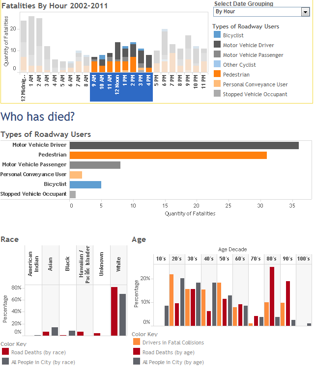
The Seattle Roadway Death Dashboard published here last week combines different sources of data and presents the data through various chart types. This interactive analytical tool provides information on roadway fatalities that could be used to save lives.

Here are some examples of how you can interact with this tool to gain insight:

  • During the daytime, people in their 80s and 90s are more likely to be killed in a traffic collision than any other age group. Together, this age group makes up 7% of the total population but accounts for 44% of the fatalities from 9am to 4pm.
    [expand title=”see screenshot”]
    Dashboard showing daytime fatalities between 9am to 4pm.

    Dashboard showing daytime fatalities between 9am to 4pm.

    [/expand]
  • Pedestrians 50 and older are disproportionately likely to be killed on Seattle roadways. Pedestrians younger than 50 count for fewer roadway fatalities than expected based on the city demographics. People aged 20-49 account for 58% of the city population but only 41% of its pedestrian fatalities.
    [expand title=”see screenshot”]
    Death dashboard showing pedestrians only by age and race.

    Death dashboard showing pedestrians only by age and race.

    [/expand]
  • As a percentage of total fatalities, black drivers are more than three times as likely to be killed on the roadway than city demographics would suggest. This race accounts for 26% of driver fatalities but only 8% of the population.
    [expand title=”see screenshot”]
    Dashboard showing drivers only by age and race.

    Dashboard showing drivers only by age and race.

    [/expand]
  • Rainier Ave S is the deadliest city street with a speed limit from 20-35 mph by far, but there are several other streets where four or more people have died.
    [expand title=”see screenshot”]
    Death Dashboard showing fatalities on roadways with 20-35 mph speed limits.

    Death Dashboard showing fatalities on roadways with 20-35 mph speed limits.

    [/expand]
  • Pedestrian fatalities are fairly evenly distributed throughout the day, while driver and passenger fatalities occur predominantly late at night and in the very early morning.
    [expand title=”see screenshot”]
    Death Dashboards showing pedestrian fatalities by hour - fairly evenly distributed.

    Death Dashboards showing pedestrian fatalities by hour – fairly evenly distributed.


    Death Dashboards showing driver and passenger fatalities by hour - mostly at night.

    Death Dashboards showing driver and passenger fatalities by hour – mostly at night.

    [/expand]

This is just a sampling of the type of analysis you can do with the dashboard. Please share any interesting results you’ve found in the comments.

Share

Seattle Roadway Death Dashboard

This dashboard provides a visualization of 299 roadway fatalities that occurred in Seattle from 2002-2011.

Share

A walker wonders: Best route from ferry terminal to Westlake?

A walker wonders:

Do your readers have the best route (least steep) from the ferry terminal to Westlake? What are the suggestions?

This is a route familiar to many tourists, or locals who have visitors. The vertical gain is over 120 feet between the waterfront, which is basically at sea level, and Westlake Center in the retail core. If you walk along the waterfront and then try to cut over at Pike, Union, or University, you’re faced with over 100 steps to climb. So, what’s a walker to do?

For those in the know, there are some elevators for parking garages near Pike Place Market that bring you from the waterfront up to Western Avenue. There’s still a hill there, or steps to climb, but the elevator cuts out half of the elevation gain.

However, my preference would be to make the uphill climb on foot. The ferry terminal exits to a walkway on Marion St, that will take you over Alaskan Way and Western Ave and straight to First Ave. First Avenue is one of the the best streets to walk along downtown in my opinion, based on the historical buildings, retail options, and its role in connecting Pike Place Market to Pioneer Square. The incline is very gradual on First and if you continue it eventually will take you to Pike or Pine from where the walk to Westlake will be relatively flat.

Share

Walking in Seattle: When the Sidewalk is Home

This is a guest post by Ray Lumpp.

When traversing the lush and rugged urban jungle of Seattle, it is not uncommon to meet a person experiencing homelessness. Many of the locals are very used to their presence, and often know the person’s name or story, but because Seattle is a city of transplants, not everyone knows how to interact with these stigmatized and misunderstood people.

If you encounter a homeless person in the street, please do not ignore them. He or she is a human being who deserves dignity and your averted glance will only make him or her feel worthless. Something as small as eye contact or a nod is all it takes. Put yourself in their shoes: those selling Real Change especially are often among the “poorest of the poor,” but at least they are working to change their situation.

If someone asks for money, consider taking them to Starbucks and buying them a sandwich or a coffee (or a gift card). While giving them cash is a personal choice, it may only allow them to continue being homeless rather than seeking a positive path out of the streets. If you have nothing to give, say something nice to brighten their day (at the very least, a simple “Sorry” will do).

Seattle has a longstanding reputation for having a large homeless population, with historically high rates of homelessness compared with its general population (8th highest in the U.S. in 2011). Some believe this is due to being the western “end of the line” for the railroads and I-90, but the truth is that Seattle supports its homeless population quite well through various foodbanks and hygiene centers, as well as temporary shelter or transitional housing.

Vital statistics (from Seattle’s Homeless Needs Assessment in 2009):

  • 70% of people experiencing homelessness in Seattle have been living without shelter for over 1 year; 23% have been living without shelter for over 6 years.
  • Nearly two thirds were living in Seattle (and 19% elsewhere in Washington) when they became homeless.
  • 60% report health conditions requiring professional care (60%)
  • 36% were hospitalized in the past year,
  • 35% reported mental health treatment in the past year, and
  • 31% were taking medications.

If you’d like to do more for people experiencing homelessness, donate clean clothes (especially shoes), books, toys, diapers, shampoo, toothpaste, toothbrushes, blankets, or old cell phones to local shelters. Volunteer at a local shelter or homeless advocacy coalition, or make a financial contribution to support their work. Shelters and feeding programs are almost always not-for-profit and run by community members looking to give back: now is your chance.

Ray Lumpp is a writer for AllTreatment.com, a website devoted to helping individuals and families facing addiction and mental health issues in Washington State.

Share

A walker wonders: Where can I walk when there are no sidewalks?

A reader sends in a tricky question about walking in Seattle where there are no sidewalks.

I live in the area colloquially called “East Ballard” or “Frelard” (etc). There are many blocks in my area that are relatively industrial in nature and don’t have sidewalks. I rarely drive and often find myself walking on these blocks (they’re hard to avoid…).

I’m wondering if there is technically a public right-of-way between the property line and the roadway for these sorts of properties. In many instances, the area between the roadway and the structure on the property is used for parking, and there is literally nowhere to walk without stepping into the street. This seems wrong to me, just on general principle. But I’m not sure if it’s technically illegal to block what would be the sidewalk if there were actually a sidewalk on the block.

Here’s SDOT’s response:

Yes, it is technically illegal to park in the area that would be a sidewalk (between the curb –or between the edge of the roadway–and the adjacent property line). A width of not less than three feet is generally assumed for this area. (Please see the code below.) Since locations vary, especially in older parts of town, we would need to inspect the area to determine the boundaries in a particular situation.

Parking over the sidewalk area is a common problem on streets with no curbs or sidewalks, and the prohibition of parking in the sidewalk area is difficult to enforce. When a curb is constructed, there is no question regarding the location of the boundary line, and most drivers will respect it. In an industrial area, businesses may be interested in supporting such a project for the safety of their customers and employees as well as for other pedestrians.

Some neighbors have joined together to request Neighborhood Street Funds from the city for this type of improvement. This generally requires strong support from the local community, including residents and businesses.

Seattle Municipal Code 11.14.570 Sidewalk.
“Sidewalk” means that area between the curb lines or the lateral edge lines of a roadway and the adjacent property, intended for the use of pedestrians or such portion of private property parallel and in proximity to a street or alley and dedicated to use by pedestrians. For the purposes of this subtitle, there is always deemed to be a sidewalk not less than three (3)feet in width, whether actually constructed or not, on each side of each street except where there is less than three (3) feet between the edge of the roadway and a physical obstruction which prohibits reasonable use by pedestrians. The sidewalk is located where constructed, or if not constructed, adjacent to the property line or as close thereto as can reasonably be used by pedestrians; provided, that no sidewalk shall be deemed to exist on private property unless it is actually constructed.

To be direct, it’s illegal to park in the area where a sidewalk would be and pedestrians who are not able to walk in the sidewalk area due to parked vehicles can call SPD. For ongoing issues, contact the Parking Enforcement Unit at 206-386-9012. They may be able to come out to investigate the situation and work to correct the issue through new signage or more regular enforcement. For more immediate attention, call SPD’s non-emergency number at 206-625-5011.

It’s unfortunate that pedestrians have to compete with drivers for area along the roadway that’s technically not for parking and not really a sidewalk. The Neighborhood Street Fund is one way to have the city build new sidewalks, but is a very competitive process that requires broad community support, which doesn’t come easily in an industrial area. SDOT doesn’t even allow industrial land-owners to fund the construction of a sidewalk by themselves.

With the cost of building all of Seattle’s missing sidewalks estimated at up to $4.5 billion, there’s no realistic solution to create lots more sidewalks. Enforcement of existing laws is the only reasonable option to improve pedestrian accessibility in areas where the infrastructure has been neglected.

Share

Walking News Roundup – 11/26

  • Seattle Pedestrian Advisory Board is looking for new members again. Here’s more information about the board and how to apply. Applications are due by December 17.
  • Queen Anne Greenways is hosting two meetings to meet others in the neighborhood and share ideas to improve walking and biking safety. The two times are: Tuesday, Nov 27, 7-8:30pm or Friday, Nov 30, 3-4:30pm at 2572 10th Ave W. Be sure to RSVP via email to Jody Lemke
  • Feet First has launched a “Rate Your Space” campaign, which uses WalkScore’s iphone app, to identify pedestrian issues that need to be addressed. The campaign will run through February 2013.
  • Feet First has a write-up on Immersus Walking Tours, which provides walking tours by foot in Seattle.
  • Feet First Walking Ambassador Mary Magenta is leading a Kubota Garden art walk on certain weekend days through January.
Share

Running Tips in Seattle

This is a guest post from Heather Roberts

Living in a city of any large size be it Seattle or any other place offers great opportunities for some scenic routes, though there are some aspects of that that may need addressing. Walking and running are great ways to stimulate ourselves and to bring back that energy and drive we all need as time goes by. There are plenty of things in the urban environment which may get in our way so here are a few useful tips on the subject that may help you out:

logo vacation rentals

  1. Use local parks
    Although this is the most obvious choice for city walks and running many people still prefer to run around the neighborhood or down certain trails. This is not necessarily a bad thing, but parks offer the best air quality in cities and they have much less factors which may interrupt your training or walking. Keep in mind that big cities often suffer from excessive pollution regardless of the best attempts of the local government and that even the small amounts of smog we inhale daily are very bad for our overall health. The colder months of the year are known for better air quality than the hot and humid days of summer, so plan accordingly. For the most part Seattle is a much cleaner and better place than, say, some parts of New York, so it isn’t much of an issue but parks are still preferable spots. A great place is Washington Park and Gas Works Park also offers a neat place to walk and run and a great view of the skyline by Lake Union.
  2. Running in town
    You can always walk and run outside parks and the usual trails though you should always be aware of the traffic being there to cut you off and get in your way. There are a lot of nice places in town where you can enjoy a change of pace from the usual paths though there are a few things you should always keep in mind and most of all safety. Avoid running or walking in places you’ve never been to after dark and always carry your ID and enough cash tucked away safely where its unlikely to be found like socks or inner pockets of clothes. The areas Downtown and around Pike and Pine streets, South Dearborn Street to Yesler Way and to the east of I-5 on Yesler Way have been reported as the most common concentration of violent crimes by the Seattle PD. The last area is known for the murder of police officer Timothy Brenton back in 2009. Being in these areas in the dead of night and cutting corners through alleys is a recipe for trouble on the wrong day. Overall Seattle is much safer than other cities like New York or LA, but you should still use common sense when walking or running after dark.
  3. Embrace the city
    Interruptions are bound to happen when you walk the streets so be patient at crosswalks and traffic lights and if you’re running use the opportunity to stretch or do some squats instead of impatiently pacing in place. The city has a flow of its own, feel its rhythm and accept it as inevitable. When you are walking make sure you take breaks and pay attention to how your feet feel – concrete and asphalt are one of the worst surfaces to walk and run on because of their poor shock-absorbing qualities. This can give you joint pain and if you’re not wearing comfortable shoes even blisters. Use your common sense and do things in moderation.

This is a guest post from Heather Roberts. If you need more interesting destinations check: http://www.vacation-rentals.com/blog

Share