Archive for the 'improvements' Category

FAQ for Seattle’s plan to reduce speeds to 20/25 mph

Seattle is poised to take a major step forward in improving roadway safety by reducing speed limits to 25 mph on arterials and 20 mph on residential streets. The plan, announced by councilmember Tim Burgess yesterday, will be presented to the City Council for a vote later this month.

This change would represent the city’s most significant action to support Vision Zero, Seattle’s plan to end traffic deaths and serious injuries by 2030, and would send a clear message that safety surmounts speed when it comes to our transportation network.

While Seattle is not the first city to consider such a change, the idea may be new to many people. Local safe street advocacy organization Seattle Neighborhood Greenways worked with the city on this legislation and has prepared a list of Frequently Asked Questions, which is re-posted below in full:

Who supports the 20/25 MPH idea?

Many community, public health, school, business, and advocacy groups are asking for safer speed limits. We hope you will too after learning more about how this idea will save lives!

What’s the idea for non arterial streets (neighborhood streets)?

A safe and livable 20 MPH speed limit for every neighborhood street in Seattle. Currently, the “default” speed on non-arterial streets is 25 MPH – faster than you probably drive on neighborhood streets. 20 MPH streets will be safer for us all, particularly people walking and kids playing.

What’s the idea for arterial streets?

Streets that are known to be dangerous should have speed limits examined, and potentially reduced to 25 MPH, as part of a comprehensive safety strategy. Additionally Communities should be able to request the city work with them to reduce arterial speed limits especially in areas such as business districts and through community hubs. Traffic should be smooth and safe and people should be able to get where they need to go reliably and safely. One part of this would be to change the “default arterial speed limit” signs at the entrances of Seattle to 25 MPH to let visitors know that they may encounter 25 MPH arterial streets.

Will changing the speed limit save lives?

Yes. Changing the speed limit will make our streets safer for everyone! Each year in Seattle about 20 people are killed in traffic collisions and another 150 are seriously injured. 42% of of these collisions involved speeding. Driving even a little slower gives us all more time to see each other and makes it easier to stop. Well-established research shows that even a small speed decrease makes a big difference. Vehicle stopping distance improves by 45 feet (23%) when traveling at 25 MPH versus 30 MPH. If a collision does happen, nine out of ten people hit by a driver going 20 MPH will survive, while at 30 MPH survival rates decrease to only five out of ten.

Will 20 MPH for neighborhood streets mean I’ll take longer to drive anywhere?

No. On non-arterial (neighborhood) streets, it is already difficult to drive faster than 20 MPH due to roundabouts and narrow street widths. When people do speed it is especially dangerous for elders and children living and playing in their neighborhoods.

Would a 25 MPH for arterial street make my commute longer?

First of all, this proposal does not change all arterial streets to 25 MPH (see FAQ above). Not likely. Most people drive during rush hour, when it’s already difficult to drive fast. Travel time is primarily determined by factors like traffic signals, congestion, and turning vehicles. Moreover, a top reason for congestion in Seattle is traffic collisions. Reducing speeds will reduce collisions and reduce the frequency of collision-related congestion. People driving outside of peak travel times may see a slight increase in their travel time. If you’re going 30 MPH without any interruptions, a lowered speed limit of 25 MPH will add about 1 minute to your trip (the average car trip in Seattle is about 3.5 miles). We think the occasional extra minute is worth it to save someone’s life.

When would the speed limits change, and which streets would be affected?

A default 20 MPH speed limit for non-arterial neighborhood streets could take effect as soon as the signs could be changed, except where they are currently signed to 15 MPH (as they are in some school zones).

The 25 MPH limit for arterial streets would be implemented on a case by case basis over time with community and SDOT evaluation (this is the model used by every other city in King County). Only then would speed limit signs be changed and a 25 MPH limit enforced.

Are there other cities with 20/25 MPH speed limits?

Yes. 20 MPH neighborhood streets are widely seen as a best practice around the world to keep neighborhoods safe and comfortable places to live in and raise families. Every other city in King County has a default speed limit of 25 MPH or lower. Many other large cities around the world, including New York, Los Angeles, Washington D.C., London, Paris, Berlin, and Tokyo, already have a speed limit set to 25 MPH or lower to improve drivers’ ability to avoid crashes.

Isn’t 20/25 MPH just a way to raise additional revenue for the City?

Not at all. Seattle should reduce its speed limit in order to make the city safer for people walking, biking, and driving. A lower speed limit helps meet the City’s goal of bringing traffic fatalities to zero. Data shows that driving at or below 25 MPH improves drivers’ ability to avoid crashes.

Sometimes streets are just dangerous. Why focus on speed?

Dangerous driver choices, such as speeding, failure to yield, and improper turns, are the primary cause or a contributing factor in 70% of pedestrian fatalities. Legislative efforts, such as lowering the speed limit, combined with engineering street safety improvements, education and enforcement work together to create safer streets for us all.

What is Vision Zero?

Seattle’s goal for traffic fatalities and serious injuries is the same you would want for you and your family: zero (this goal is called Vision Zero). While zero fatalities may seem ambitious, it’s the same standard we expect of our airline system. 20/25 MPH is a great way to improve drivers’ ability to avoid crashes!

Share

Solutions Coming for Missing Sidewalks in Seattle

Note: This cross-post is available in its entirety at The Urbanist.

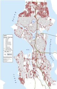
Missing Sidewalks in Seattle

Missing sidewalks in Seattle

There may be solutions soon for one of Seattle’s longest-lasting infrastructure problems. Since the middle of last century when the city annexed land in what is now north Seattle, little progress has been made in building hundreds of miles of missing sidewalks in North Seattle and across the city. North Seattle residents who voted for annexation claim that the city promised sidewalks and failed to deliver. A multi-billion dollar price tag to build all missing sidewalks has been too intimidating for anyone to find real solutions.

However, after decades of minimal progress, wholesale solutions to bring sidewalks to Seattle may be closer than ever. While most conversations about this problem have been around building traditional concrete sidewalks, the Seattle Department of Transportation is now evaluating more affordable alternatives. And, to overcome the funding gulf that remains, city council candidate Sandy Brown has a potential answer.

Read the rest at The Urbanist

Share

A few local walking news links

A number of good quality links to share:

Share

Walking news roundup – 4/4

More walking-related news from the area:

  • Pedestrian improvements will be completed by early April on NW 90th Street between 13th and 14th Avenues NW. Improvements include wider sidewalks, improvements to curbs and planter strips, as well as providing safer access to local schools, services, and bus rapid transit. Click here to see details and a map.
  • Undriving, the Seattle-based organization that issues undriving licenses has won a national advocacy award for “joyful enthusiasm” (via Seattle Bike Blog)
  • The Duwamish Trail has opened:

    Looking for an easy walk or bike ride? Try the Duwamish Trail, approximately two-and-a-half miles along the west side of the Duwamish River in West Seattle. It’s a wonderfully flat trail, starting from the lower South Spokane Street Bridge, following West Marginal Way Southwest, southward to the First Avenue South Bridge.

  • Summer streets schedule has been released, including Ballard, Alki, Greenwood/Phinney, Rainier valley
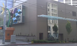
  • On your next walk, check out the Paper Mache creature sinstalled near Hing Hay Park
  • Feet First has an urban greenway ramble planned for 4/11:

    This walk will begin with a tour of the Children’s Playgarden, and then follow the Mountains to Sound greenway to Lewis Park on Beacon Hill, passing little known parks and stunning viewpoints along the way. The walk will conclude with a visit to Jimi Hendrix Park, adjacent to the Northwest African American Museum, where plans for this new community gathering space will be discussed.

  • Join Feet First, Latona Pub, and Seattle-based brewery Two Beers for a beer-drinking Earth Day celebration:

    You are invited to join this unique Earth Day celebration highlighting the work of beer lovers and supporting our people powered movement. This one of a kind event benefits Feet First, the only organization in Washington working to ensure there are walkable communities across the state. Your ticket gets you a Feet First pint glass, a big frothy mug of Two Beer’s limited edition Hand Truckin’ Wheat Ale, and the chance to toast Mother Earth with craft brewers and pedestrian advocates.

Share

Road diet on Nickerson found to improve safety, will other streets get a road diet?

SDOT has released a report on the Nickerson St road diet and found that by reducing the number of lanes for cars, safety has improved. Collisions, overall vehicle speeds, and the number of speeders have been reduced with minimal impact to traffic volumes. The Mayor outlines the good news:

Completed by the City in August 2010, the modifications have produced the following results:

  • Reduced collisions by 23 percent over a one-year period (compared to the previous five-year average)
  • Motorists traveling over the speed limit have declined by more than 60 percent
  • Top-end speeders (people traveling 10 or more miles over the speed limit) have fallen by 90 percent
  • The 85th percentile speed dropped from 40 mph and 44 mph westbound and eastbound to 33 mph and 33 Westbound and Eastbound. This is an 18 and a 24% reduction in speed.
  • Traffic volumes remain roughly the same with no evidence of traffic diversion.

This is the 27th successful road diet implemented by SDOT since 1974. And, with yet another roadway safety measure in place, the question must be asked: why isn’t SDOT implementing more of these safety measures?

We recently pointed out that 28 pedestrians have died in locations that may be eligible for a road diet. Since then, we’ve profiled three streets that may be ideal candidates for SDOT to consider next: 35th Ave SW in West Seattle, 23rd Ave in the Central District / Judkins Park, and S Jackson St in the International District. Let’s compare these three streets with Nickerson St to see whether these other streets may deserve the same successful safety treatment as Nickerson and 26 other Seattle streets.

First, we’ll start by looking at traffic volumes. SDOT looks at the total number of cars that use a roadway before implementing a road diet. Streets with average daily traffic counts above 25,000 are not good candidates, and presumably lower volumes make for better candidates, though road diets have minimal impact on overall volume. Using SDOT’s 2010 traffic volumes, here are the four streets compared, from lowest volume to highest:

  1. Jackson St: ranges from 10,200-13,600
  2. 23rd Ave: 13,400
  3. 35th Ave SW: ranges from 16,100-22,700
  4. Nickerson St: 22,300

Let’s look at another metric. While Walk Score is not an official criteria used by SDOT, it indicates the walkability of a location and is correlated with the number of pedestrians in an area. Streets with more pedestrians may be more deserving of measures that make the pedestrian environment safer and more pleasant. We took a sample Walk Score of 2-3 locations along each of these streets and are ranking them from highest (most walkable) to lowest (least walkable).

  1. Jackson St: 90
  2. 23rd Ave: 86
  3. Nickerson St: 81
  4. 35th Ave SW: 75

While the last two comparisons were interesting, the primary purpose of a lane rechannelization is to improve safety and the most dangerous streets should be looked at the hardest. We looked at this map of nationwide road fatalities, and counted the deaths that have occurred on each of these roadways from 2001-2009 to rank them in terms of urgency for safety improvements:

  1. 35th Ave SW: 4 roadway fatalities (including 2 dead peds)
  2. 23rd Ave: 4 roadway fatalities (2 dead peds)
  3. Jackson St: 3 roadway fatalities (3 dead peds)
  4. Nickerson St: 1 roadway fatality (0 dead peds)

Of our comparison group, Nickerson St has been the safest, is the second least walkable, and has the highest traffic volume. Still, a road diet was implemented and now has been shown to be a success. If a road diet can work there, then surely it can work on these other streets. How many more people will have to die before SDOT implements road diets on 35th Ave SW, 23rd Ave, Jackson St, and other locations where people are killed on Seattle’s roads?

Share

Stairway reconstruction at NE 90th Street and Ravenna Ave NE

The stairway is being reconstructed at NE 90th Street and Ravenna Ave NE, starting this week. From SDOT:

SEATTLE—Seattle Department of Transportation’s Roadway Structures crews will construct a new staircase beginning Monday, February 27, and expect to complete the work before the end of April. The stairway will be closed starting Monday, 24 hours a day, seven days a week until completion. A map of the pedestrian detour will be posted at the top and bottom of the stairway.

The crews will demolish the old staircase, install form work, and then pour concrete for the new stairs and walkway.

The stairway was built in 1940 and does not meet current standards. This project is part of SDOT’s program to upgrade the 507 stairways that SDOT owns and is responsible for maintaining. The funding is provided by the Bridging the Gap transportation initiative.

Share

Sheraton Garden Walk complete

Sheraton Garden Walk

Sheraton Garden Walk at 7th and Union

The wall of the Sheraton Hotel used to impose one of the most monolithic streetscapes in the city on downtown pedestrians along 7th Avenue. However, over the past several months, a more interesting and engaging facade has been constructed. The project cost $2 million and, while it doesn’t turn 7th Ave into a lively shop-lined street, it still provides a significant enhancement to a dead zone within downtown. The Daily Journal of Commerce has a writeup on the Sheraton Garden Walk.

[T]he recently completed streetscape is designed to complement the urban fabric, while also amplifying its connections to its unique surroundings in a way that is playful and engaging.

[Landscape Architects, Gustafson Guthrie Nichol]’s design “borrows” key pedestrian assets from across the street and playfully simulates a traditionally two-sided street. A series of massive mirror panels — emulating vertical architectural bays in scale and proportion — are strategically placed to present the illusion of rich historic facades on the face of the simple concrete wall.

The mirrors reflect the historic facade of the Eagles Auditorium Building across the street, thereby replacing the blank wall of the Sheraton with the illusion of a much grander sense of architecture. The width of the mirror panels subtly offers the familiar module of storefront windows to passing pedestrians. The mirrors also “double” the apparent pedestrian activity on the treated side of the street.

The intent of the Sheraton Garden Walk is to create the illusion of being surrounded by green without truly enclosing the space — transitioning from a typical city sidewalk to a more welcoming, garden-scale environment that emphasizes “people space” over “car space.”

In order to balance the mirrors with reality, they are framed by rustic texture and seasonal interest, provided by vines that will soon grow to clad the remaining concrete facade. As they grow in, the lush plantings will wrap and embrace the sidewalk environment for maximum effect.

Share

Infrastructure improvement updates

Here’s a rundown of current and recently completed SDOT projects that promote pedestrian mobility:

Share

Greenwood alley makeover tomorrow

Tired of potholes in your alley? Check out this do-it-yourself project these Greenwood residents are doing (via Feet First):

Thirteen Greenwood neighbors in Seattle are giving their alley a makeover. After only 3 months of conversation (not a whole lot of process in Seattle terms), these neighbors have come together with $450 ($35 each) to pour crushed rock along the alley between 95th and 97th in the Seattle Greenwood neighborhood.

The folks in this neighborhood knew it would probably be many years before the city would fix the potholes and the puddles of water that accumulate during a rainfall, so they decided to take matters into their own hands. And, without a large transportation budget, they are making it a lot easier for people to use this public right of way.

On Saturday, May 14th at 12pm at the alley at 95th and 97th between Phinney and Dayton, residents are coming together to spread the crushed rock along their alley. Alleys are gaining popularity as their appearance–narrow spaces that move people, create connections, which inspire a new way for people to see their neighborhood. Come out and learn about this neighborhood’s DIY transportation improvement that will inspire you to do some street repair in your neighborhood!

Share

Improvements on Aurora

As part of the Aurora Traffic Safety project, which has been reviewed here (part 1, part 2), the intersection with Halladay St will be improved. This intersection has one of the highest amounts of crashes for motor vehicles (nearly 20 per year), and also poses danger to pedestrians due to vehicles turning off Aurora at a high rate of speed. The new traffic island at this intersection will be constructed with concrete and feature new curb ramps and a better walking surface for pedestrians.

Additionally, radar speed limit signs will be installed at five locations along Aurora. These signs have been shown to reduce vehicle speeds by 3-5 miles per hour. The high speed of traffic along Aurora is one reason why it has so many fatalities.

Share